Policy & Water Resource Management

Policy-makers and water resource managers need periodic, if not constant, monitoring of water quality parameters. This need arises from the obligations pending on EU Member States to assess water quality and report on results periodically, as mandated by the Water Framework Directive.[1] EOMORES services prove particularly suitable in monitoring changes in water quality and the timeframes of algal blooms, due to the use of Earth Observation data. The services can offer a more reliable and potentially cheaper data collection method.
What is the problem?
The Water Framework Directive prescribes routine monitoring of inland, transitional, coastal and groundwaters. At the same time, small scale or remote inland waters can often be difficult for experts to access, making it expensive and time consuming to carry out in situ monitoring campaigns on a regular basis.
How does EOMORES address it?
The EOMORES services can potentially provide solutions for water resource management and policy through products such as high-resolution time series and maps based on Earth observation data. These products can fill the gaps generated by routine monitoring and provide detailed spatial insights, including on remote and otherwise inaccessible water bodies. Moreover, the EOMORES products capture season-driven changes in phytoplankton and harmful algae bloom timelines which might easily be missed with traditional monitoring techniques.
EOMORES services provide:
- EO historical and near-real time maps of water quality parameters (surface temperature, total suspended matter, chlorophyll-a – proxy for phytoplankton biomass);
- Quantification of phytoplankton biomass;
- Automated retrieval of e.g. WFD ecological status for phytoplankton biomass and transparency;
- Identification of algal bloom presence and timeframes;
- Spatial data, also for remote and inaccessible water bodies;
- Near-real time water quality monitoring of drinking water reservoirs.
Which products are available?
Some of the relevant available products include: the mapping of 1) phytoplankton biomass, 2) total suspended matter, 3) coloured dissolved organic matter and denser time series in support of the Water Framework Directive assessments.
[1] Directive 2000/60/EC of the European Parliament and of the Council establishing a framework for the Community action in the field of water policy
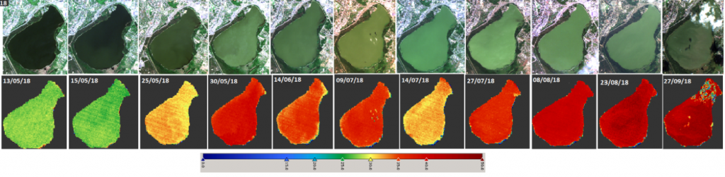
EOMORES in action: Monitoring phytoplankton in a drinking water reservoir: the case of Lake Ülemiste (Estonia)
Lake Ülemiste is a natural shallow lake with spontaneously occurring cyanobacterial blooms. The water treatment plant is located on the lake’s North-East coast and provides for about 90% of the overall drinking water supply of the city of Tallinn.

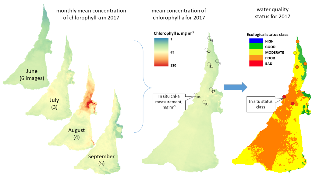
EOMORES in action: Monthly mean imagery and derived ecological status maps for the Water Framework Directive reporting (Curonian Lagoon, Lithuania)